|
|
|
| Visitors |
|
|
| Locals |
|
|
|
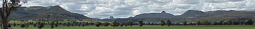
The Picture
23rd October 1999 This is a picture of the Warrumbungles as seen from behind the Tooraweenah Public School, looking north east up the Tooraweenah valley. The hill on the left is not labelled on the map, and is usually called Ned's Hill, because Ned owns the land. The distant volcanic core to the left of centre is the Breadknife, and Belougery Spire. The next peak along is Tonduran Spire.
|